LAUNCH DAY!
It’s been a long time coming, but we've finally built a working balloon and were ready to let it fly. This post will
discuss the launch day events, launch, tracking, and recovery. The weather was
great, not a cloud in the sky. The Weathered Warriors team started a little
slow the morning of the launch, but that didn't stop us. The team made its way just
South of Coldwater, Michigan where our flight simulation software predicted the
best launch site. The team used the following website with our payload specifications
and current weather predictions to model a simulated flight of our balloon: UM balloon sim.
Upon reaching the launch site Adam
began setting up the ground communication systems while Jason and Guy prepared
the payloads for launch. A final brief
test of payload systems was carried out in the parking lot of an elementary
school just south of Coldwater, MI. An initial test of the systems showed good
results. The aerocomm was sending the sensor data clearly. A few minutes wait,
a GPS lock was attained with about 9 satellites relaying data. The payload was
shut off to conserve power until just before launch. Guy and Jason secured the
payloads to each other using quick links and nylon string.
The Weathered Warriors’ balloon was the last of four to
launch. With preparations made, all payloads were powered on and secured. The Microtrak
was being picked up by our ground station and igating perfectly with aprs.fi.
The cell tracker was responding with accurate GPS coordinates when prompted and
the accutracking website had the location locked. The aerocomm system wasn’t
relaying information however. The system had worked great in the parking lot,
but not that the balloon was 50 yards away on the lawn of the elementary school
the comms system had ceased to function. At this point, our balloon was almost
inflated and we had no choice but to launch and hope the problem was just a
line of sight issue. This turned out not to be the problem as the aerocomm
system did not receive another transmission for the remainder of the day.
Immediately after the launch, we packed up and took off
toward the predicted landing site. The cell tracker stopped responding to our
texts for GPS coordinates once it lost cellular signal which occurred at about
10,000 ft. The Microtrak however did function and relayed an updated ping to
our ground station every minute. Some signals were not received however we
never went longer than five minutes at a time without receiving a new message.
Below is a screen shot of the flight data which can be found at aprs.fi with
the call sign KD8WZP.
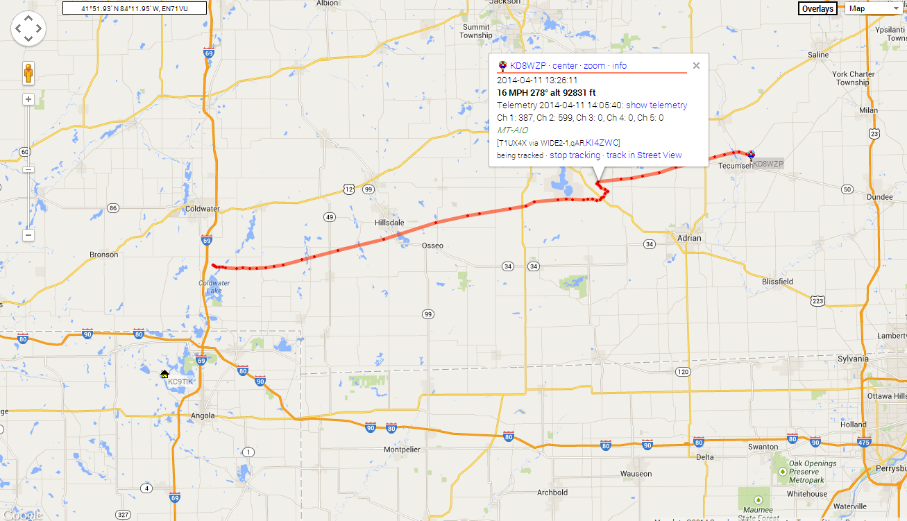
The balloon popped somewhere over US-223 and reached a
maximum measured altitude of 93,000 feet. The balloon landed on the northern
side of Tecumseh, MI a few miles short of the prediction. We believe the parachute
was tangle and only partially deployed during the decent. This faster decent
caused the balloon to land short of the target area. All parts of the balloon
were recovered except for the FTU which had been lost somewhere along the
flight.
A final note to make about the recovery would be to say that when the balloon landed we were still a few miles away driving through the town of Tecumseh. Below 800 feet, we stopped receiving messages from the Microtrak. We think that this was due to a lack of line of sight with the Microtrak and our ground station in the car. We knew the general location of the landing site, but not the exact location. However at this point, the cell tracker had regained service and began responding to the several texts which were sent to it while in flight. The cell tracker was used to give us the exact GPS coordinates of the payload after it had landed. We used a google maps app on a cell phone to track down the payload on foot which made recovery a breeze. We found it almost immediately. Luckily the payload landed in an open field not more than 200 yards away from a road.
A final note to make about the recovery would be to say that when the balloon landed we were still a few miles away driving through the town of Tecumseh. Below 800 feet, we stopped receiving messages from the Microtrak. We think that this was due to a lack of line of sight with the Microtrak and our ground station in the car. We knew the general location of the landing site, but not the exact location. However at this point, the cell tracker had regained service and began responding to the several texts which were sent to it while in flight. The cell tracker was used to give us the exact GPS coordinates of the payload after it had landed. We used a google maps app on a cell phone to track down the payload on foot which made recovery a breeze. We found it almost immediately. Luckily the payload landed in an open field not more than 200 yards away from a road.
No comments:
Post a Comment